NOTICE OF REGULAR MEETING AND PUBLIC HEARING BY THE CITY COUNCIL OF THE CITY OF VICTOR, IDAHO, TO CONSIDER THE URBAN RENEWAL PLAN FOR THE VICTOR NORTH URBAN RENEWAL PROJECT OF THE URBAN RENEWAL AGENCY OF THE CITY OF VICTOR
NOTICE OF REGULAR MEETING AND PUBLIC HEARING BY THE
CITY COUNCIL OF THE CITY OF VICTOR, IDAHO,
TO CONSIDER THE URBAN RENEWAL PLAN FOR THE
VICTOR NORTH URBAN RENEWAL PROJECT
OF THE URBAN RENEWAL AGENCY OF THE CITY OF VICTOR
NOTICE IS HEREBY GIVEN that on Wednesday, November 13, 2024, at 6:00 p.m., in the City Council Chambers, Victor City Hall, 138 North Main Street, Victor, Idaho, 83455, the City Council (the “City Council”) of the City of Victor (the “City”) will hold during its regular meeting, a public hearing to consider for adoption the proposed Urban Renewal Plan for the Victor North Urban Renewal Project (the “Plan”) of the Urban Renewal Agency of the City of Victor, Idaho (the “Agency”). The urban renewal and revenue allocation area boundary is coterminous and is hereinafter described. The Plan proposes that the Agency undertake urban renewal projects, including identifying public facilities for funding, pursuant to the Idaho Urban Renewal Law of 1965, Chapter 20, Title 50, Idaho Code, as amended. The Plan being considered for adoption contains a revenue allocation financing provision pursuant to the Local Economic Development Act, Chapter 29, Title 50, Idaho Code, as amended, that will cause property taxes resulting from any increase in equalized assessed valuation in excess of the equalized assessed valuation as shown on the base assessment roll as of January 1, 2024, to be allocated to the Agency for urban renewal purposes. The Agency has adopted and recommended approval of the Plan. The City Council will also consider the first reading of an ordinance to adopt the Plan at the meeting scheduled for November 13, 2024, at 6:00 p.m. Additional readings and/or adoption of the ordinance will follow consistent with the City’s ordinance approval process.
The general scope and objectives of the Plan are:
a. The engineering, design, installation, construction, and/or reconstruction of storm water management infrastructure to support compliance with federal, state, and local regulations for storm water discharge and to support private development;
b. The provision for participation by property owners and developers within the Project Area to achieve the objectives of this Plan;
c. The engineering, design, installation, construction, and/or reconstruction of the transportation network within the Project Area, including all streets and streetscapes within the Project Area, with a focus on enhancements, road improvements including paving of existing roads, helping to develop new roads, installation of traffic control devices, and other road and street improvements as needed, and related pedestrian facilities, curb and gutter, and intersection improvements, and traffic signals (if needed);
d. The engineering, design, installation, construction and/or reconstruction of sidewalks and related pedestrian facilities, curb and gutter and streetscapes, which for purposes of this Plan, the term streetscapes include sidewalks, lighting, landscaping, benches, signage, way-finding, bike racks, public art, and similar amenities between the curb and right-of-way line; and other public improvements, including multi-use pathways with landscape buffers and public open spaces;
e. The engineering, design, installation, construction, and/or reconstruction of utilities including but not limited to improvements and upgrades to the water distribution system, including extension of the water distribution system, water capacity improvements, water storage upgrades, wastewater system improvements and upgrades, including extension of the wastewater collection system, lift station, and improvements, and upgrades to power, gas, fiber optics, communications and other such facilities;
f. The engineering, design, installation, construction, and/or reconstruction of public parking facilities, including structured parking facilities;
g. Removal, burying, or relocation of overhead utilities; removal or relocation of underground utilities; extension of electrical distribution lines and transformers; improvement of irrigation canals and drainage ditches and laterals; undergrounding or piping of laterals; addition of fiber optic lines or other communication systems; public parking facilities, and other public improvements, including but not limited to, fire protection systems, floodway and flood zone mitigation; and other public improvements that may be deemed appropriate by the Board;
h. The acquisition of real property for public right-of-way and streetscape improvements, utility undergrounding, extension, upgrades, public parks and trails, pedestrian facilities, pathways and trails, recreational access points and to encourage and enhance housing affordability and housing diversity, enhance transportation and mobility options, decrease underutilized parcels and surface parking lots, create development opportunities consistent with the Plan, including but not limited to future disposition to qualified developers for qualified developments;
i. The disposition of real property through a competitive process in accordance with this Plan, Idaho law, including Idaho Code § 50-2011, and any disposition policies adopted by the Agency;
j. The demolition or removal of certain buildings and/or improvements for public rights-of-way and streetscape improvements, pedestrian facilities, utility undergrounding extension and upgrades, public parks and trails, public facilities, and to encourage and enhance housing affordability and housing diversity, enhance transportation and mobility options, decrease underutilized parcels and surface parking lots, to eliminate unhealthful, unsanitary, or unsafe conditions, eliminate obsolete or other uses detrimental to the public welfare or otherwise to remove or to prevent the spread of deteriorating or deteriorated conditions;
k. The management of any property acquired by and under the ownership and control of the Agency;
l. The development or redevelopment of land by private enterprise or public agencies for uses in accordance with this Plan;
m. The construction and financial support of infrastructure necessary for the provision of improved transit and alternative transportation;
n. The engineering, design, installation, construction, and/or reconstruction of below ground infrastructure to support the construction of certain municipal buildings pursuant to Idaho Code § 50-2905A;
o. The provision of financial and other assistance to encourage and attract business enterprise including but not limited to start-ups and microbusinesses, mid-sized companies and large-scale corporations and industries;
p. The provision of financial and other assistance to encourage greater density and a diverse mix of rental rates and housing options, including affordable and workforce housing;
q. The rehabilitation of structures and improvements by present owners, their successors, and the Agency;
r. The preservation and/or restoration of historic and/or cultural assets as amenities, including but not limited to façade restoration;
s. The preparation and assembly of adequate sites for the development and construction of facilities for housing, retail areas, cultural centers, commercial, and governmental use;
t. City to amend zoning regulations (if necessary) and standards and guidelines for the design of streetscape, festival streets, multi-use pathways, parks, trails, plazas and open space and other like public spaces applicable to the Project Area as needed to support implementation of this Plan;
u. In conjunction with the City, the establishment and implementation of performance criteria to assure high site design standards and environmental quality and other design elements which provide unity and integrity to the entire Project Area, including commitment of funds for planning studies, achieving high standards of development, and leveraging such development to achieve public objectives and efficient use of scarce resources;
v. To the extent allowed by law, lend or invest federal funds to facilitate development and/or redevelopment;
w. The provision for relocation assistance to displaced Project Area occupants, as required by law, or within the discretion of the Agency Board for displaced businesses;
x. Agency and/or owner-developer construction, participation in the construction and/or management of public parking facilities and/or surface lots that support a desired level and form of development to enhance the vitality of the Project Area;
y. Agency participation in the environmental assessment and remediation of brownfield sites, or sites where environmental conditions detrimental to development and/or redevelopment exist within the Project Area;
z. Other related improvements to those set forth above as further set forth in Attachments 5.
Any such land uses as described in the Plan will be in conformance with zoning for the City and the City’s Comprehensive Plan, ReEnvision Victor, as adopted by the City Council, or as may be applicable. Land made available will be developed by private enterprises or public agencies as authorized by law. The Plan identifies various public and private improvements which may be made within the Project Area.
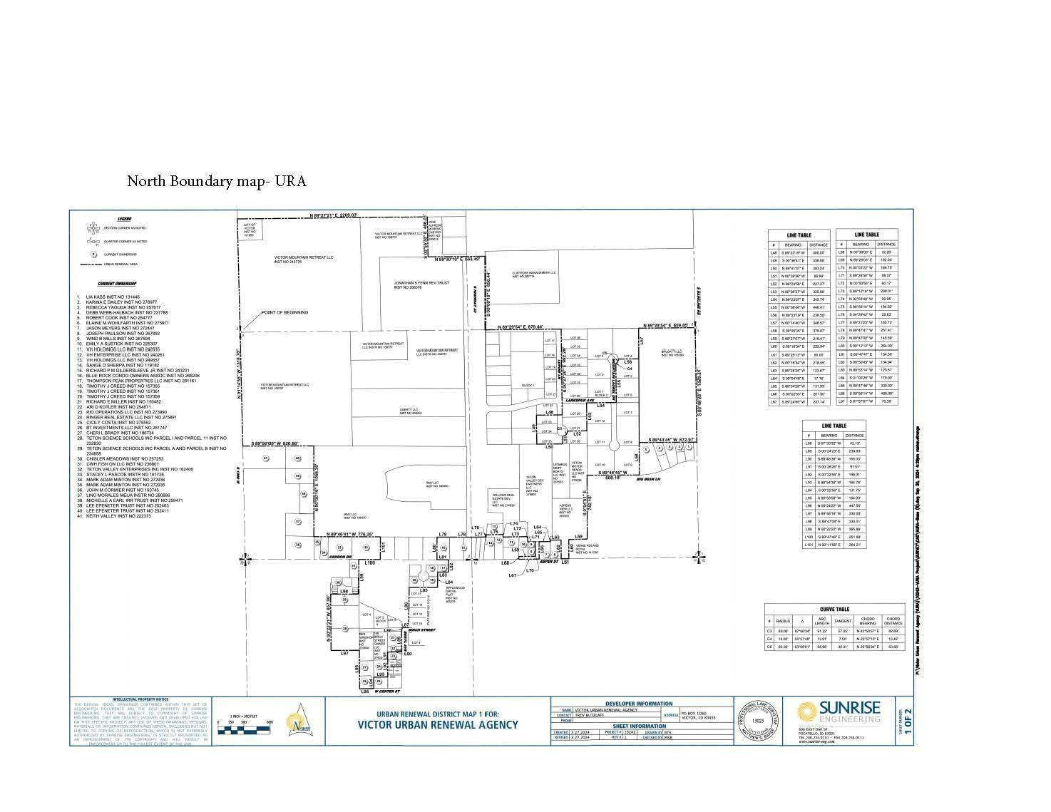
The Urban Renewal Project Area and Revenue Allocation Area herein referred to is generally described as follows:
The an area in the City consisting of 84 parcels of property totaling approximately 354.5 acres with parcels ranging in size from 0.46 to 31.62 acres, generally located Between S 1000 W and S Baseline Road and south of W 7000 S, west of Beryl Ave and North of Center Street including outer boundaries of rights-of-way.
The Project Area and Revenue Allocation Area is more particularly described as follows:
AN URBAN RENEWAL DISTRICT, LOCATED IN THE NORTHWEST QUARTER OF SECTION 11 AND SECTION 2, TOWNSHIP 3 NORTH RANGE 45 EAST, BOISE MERIDIAN, TETON COUNTY, IDAHO, DESCRIBED AS FOLLOWS:
BEGINNING AT THE WEST 1/4 CORNER OF SECTION 2, BEING MONUMENTED BY A 5/8” IRON ROD WITH 3” ALUMINUM CAP STAMPED AS DESCRIBED IN CORNER PERPETUATION AND FILING INST. NO. 282741
THENCE NORTH 01°22’21” WEST ALONG THE WEST LINE OF SECTION 2, A DISTANCE OF 1320.97 FEET TO A THE NORTHWEST CORNER OF A PARCEL OF LAND DESCRIBED IN INSTRUMENT NUMBER 191990;
THENCE NORTH 89°27’21” EAST A DISTANCE OF 2209.03 FEET ALONG THE NORTH BOUNDARY LINES OF THE FOLLOWING THREE (3) PARCELS OF LAND AS DESCRIBED BY THEIR INSTRUMENT NUMBERS LISTED BELOW, TO THE NORTHWEST CORNER OF A PARCEL OF LAND DESCRIBED IN INSTRUMENT NUMBER 283015
- 191990
- 243776
- 168737
THENCE SOUTH 00°56’38” EAST, ALONG THE WEST BOUNDARY OF SAID PARCEL, A DISTANCE OF 466.01 FEET TO THE SOUTHWEST CORNER OF A PARCEL OF LAND DESCRIBED IN INSTRUMENT NUMBER 283015, ALSO BEING ON THE NORTH BOUNDARY OF A PARCEL OF LAND DESCRIBED IN INSTRUMENT NUMBER 266376;
THENCE NORTH 89°30’10” EAST A DISTANCE OF 663.49 FEET TO THE EAST RIGHT OF WAY OF HIGHWAY 33;
THENCE SOUTH 00°00’16” EAST, ALONG SAID EAST RIGHT OF WAY, A DISTANCE OF 856.44 FEET TO A POINT ON THE LATITUDINAL CENTERLINE OF SECTION 2;
THENCE NORTH 89°29’54” EAST, ALONG THE LATITUDINAL CENTERLINE OF SECTION 2, A DISTANCE OF 879.44 FEET TO A POINT ON THE EAST RIGHT OF WAY OF LUPINE LANE;
THENCE SOUTH 00°37’20” EAST, ALONG THE EAST RIGHT OF WAY OF LUPINE LANE, A DISTANCE OF 992.26 FEET TO A POINT ON THE WEST BOUNDARY OF LOT 29 BLOCK 1 AS SHOWN ON THE BOUNDARY ADJUSTMENT AMENDED PLAT OF TETON TOWNE CENTER SUBDIVISION, AS SHOWN ON THE RECORDED PLAT THEREOF, INSTRUMENT NUMBER 152867
THENCE SOUTH 89°23’19” WEST 300.00 FEET TO A POINT ON THE WEST BOUNDARY OF LOT 23 BLOCK 1 OF THE TETON TOWNE CENTER SUBDIVISION AS SHOWN ON THE OFFICIAL PLAT THEREOF, INSTRUMENT NUMBER 124177, POINT BEING THE NORTHWEST CORNER OF SAID LOT 23;
THENCE S 00°36’41” EAST, ALONG THE WEST BOUNDARY LINES OF LOTS 23, 24, AND 25 OF BLOCK ONE OF SAID TETON TOWNE CENTER SUBDIVISION, A DISTANCE OF 336.88 FEET TO A POINT ON THE SOUTH LINE OF SAID TETON TOWNE CENTER, POINT ALSO BEING THE SOUTHWEST CORNER OF LOT 25;
THENCE NORTH 89°41’37” EAST, ALONG THE SOUTH LINE OF SAID LOT 25 BLOCK ONE, A DISTANCE OF 303.24 FEET TO THE SOUTHEAST CORNER OF SAID LOT 25;
THENCE NORTH 00°39’36” WEST A DISTANCE OF 88.99 FEET TO A POINT OF CURVATURE WITH A 60.00-FOOT-RADIUS NON-TANGENT CURVE WHOSE CENTER BEARS NORTH 03°36’06” WEST;
THENCE FOLLOWING ALONG SAID CURVE COUNTERCLOCKWISE FOR AN ARC LENGTH OF 91.22 FEET THROUGH A CENTRAL ANGLE OF 87°06’34” (THE CHORD OF SAID CURVE BEARS NORTH 42°50’37” EAST A DISTANCE OF 82.69 FEET) TO A POINT OF NON-TANGENCY ON THE SOUTH LINE OF LOT 27, BLOCK 1 OF THE BOUNDARY ADJUSTMENT AMENDED PLAT OF TETON TOWNE CENTER SUBDIVISION AS SHOWN IN INSTRUMENT NUMBER 152867;
THENCE NORTH 89°23’56” EAST, ALONG THE SOUTH BOUNDARY LINE OF SAID LOT 27, A DISTANCE OF 227.27 FEET TO THE SOUTHEAST CORNER OF SAID LOT 27;
THENCE NORTH 00°36’37” WEST, ALONG THE EAST BOUNDARY LINES OF LOTS 27 AND 29 OF BLOCK ONE OF SAID BOUNDARY ADJUSTMENT AMENDED PLAT OF TETON TOWNE CENTER SUBDIVISION, A DISTANCE OF 325.08 FEET TO A POINT ON THE SOUTHERLY RIGHT OF WAY OF LARKSPUR AVENUE;
THENCE NORTH 89°23’27” EAST, ALONG SAID SOUTHERLY RIGHT OF WAY, A DISTANCE OF 345.74 FEET TO A POINT ON THE EASTERLY RIGHT OF WAY OF MOUNTAIN LAUREL DRIVE
THENCE NORTH 00°36’44” WEST, ALONG SAID EASTERLY RIGHT OF WAY, A DISTANCE OF 446.41 FEET TO A POINT OF CURVATURE WITH A 15.00-FOOT-RADIUS CURVE WHOSE CENTER BEARS NORTH 89°23’16” EAST;
THENCE FOLLOWING ALONG SAID CURVE CLOCKWISE FOR AN ARC DISTANCE OF 13.91 FEET THROUGH A CENTRAL ANGLE OF 53°07’48” (THE CHORD OF SAID CURVE BEARS NORTH 25°57’10” EAST A DISTANCE OF 13.42 FEET) TO A POINT OF REVERSE CURVATURE WITH A 60.00-FOOT- RADIUS CURVE WHOSE CENTER BEARS NORTH 37°28’56” WEST;
THENCE FOLLOWING ALONG SAID CURVE COUNTERCLOCKWISE FOR AN ARC LENGTH OF 55.66 FEET THROUGH A CENTRAL ANGLE OF 53°09’01” (THE CHORD OF SAID CURVE BEARS NORTH 25°56’34” EAST A DISTANCE OF 53.68 FEET) TO A POINT ON THE SOUTH LINE OF LOT 4, BLOCK 2 OF SAID TETON TOWNE CENTER SUBDIVISION;
THENCE NORTH 89°23’19” EAST A DISTANCE OF 238.58 FEET TO THE SOUTHEAST CORNER OF SAID LOT 4;
THENCE NORTH 00°14’40” WEST, ALONG THE EAST LINE OF SAID LOT 4 BLOCK 2, A DISTANCE OF 348.57 FEET TO A POINT ON THE LATITUDINAL CENTERLINE OF SECTION 2;
THENCE NORTH 89°29’54” EAST, ALONG SAID LATITUDINAL CENTERLINE OF SECTION 2, A DISTANCE OF 659.85 FEET TO THE EAST 1/4 CORNER OF SECTION 2 (FOR MORE INFORMATION, SEE CORNER PERPETUATION AND FILING INSTRUMENT NUMBER 272921);
THENCE SOUTH 00°48’28” EAST, ALONG THE EAST LINE OF SECTION 2, A DISTANCE OF 1326.24 FEET TO A POINT;
THENCE SOUTH 89°43’45” WEST, ALONG THE SOUTH LINE OF A PARCEL OF LAND DESCRIBED IN INSTRUMENT NUMBER 165779, A DISTANCE OF 672.97 FEET TO A POINT ON THE EASTERLY BOUNDARY OF THE TETON TOWNE CENTER SUBDIVISION, AS SHOWN ON THE RECORDED PLAT THEREOF, INSTRUMENT NUMBER 124177;
THENCE SOUTH 00°05’35” EAST, ALONG SAID EASTERLY BOUNDARY, A DISTANCE OF 378.87 FEET TO A POINT ON THE SOUTHERLY BOUNDARY OF TETON TOWNE CENTER SUBDIVISION, POINT BEING THE SOUTHEAST CORNER OF LOT 9, BLOCK 2 OF SAID TETON TOWNE CENTER SUBDIVISION;
THENCE SOUTH 89°46’45” WEST, ALONG SAID SOUTHERLY BOUNDARY, A DISTANCE OF 608.18 FEET TO A POINT ON THE EASTERLY BOUNDARY OF A PARCEL OF LAND DESCRIBED IN INSTRUMENT NUMBER 279336, POINT ALSO BEING THE SOUTHWEST CORNER OF LOT 10, BLOCK 2 OF SAID TETON TOWNE CENTER SUBDIVISION;
THENCE SOUTH 00°04’51” EAST, FOLLOWING ALONG SAID EAST BOUNDARY LINE AND THE EAST BOUNDARY LINE OF A PARCEL OF LAND DESCRIBED IN INSTRUMENT NUMBER 281631, A DISTANCE OF 742.18 FEET TO THE NORTHEAST CORNER OF A PARCEL OF LAND DESCRIBED IN INSTRUMENT NUMBER 141766;
THENCE SOUTH 88°27’07” WEST, ALONG THE NORTH BOUNDARY OF SAID PARCEL, A DISTANCE OF 216.41 FEET TO A THE NORTHWEST CORNER OF SAID PARCEL;
THENCE SOUTH 00°16’34” EAST, ALONG THE WEST BOUNDARY LINE OF SAID PARCEL, A DISTANCE OF 222.94 FEET TO A POINT ON THE NORTH LINE OF SECTION 11, POINT BEING THE SOUTHWEST CORNER OF SAID PARCEL;
THENCE SOUTH 89°25’13” WEST, ALONG THE NORTH LINE OF SECTION 11, A DISTANCE OF 90.00 FEET TO THE SOUTHEAST CORNER OF A PARCEL OF LAND DESCRIBED IN INSTRUMENT NUMBER 275971;
THENCE NORTH 00°16’34” WEST, ALONG THE EAST BOUNDARY OF SAID PARCEL, A DISTANCE OF 218.55 FEET TO THE NORTHEAST CORNER OF SAID PARCEL;
THENCE SOUTH 89°28’28” WEST, ALONG THE NORTH LINE OF SAID PARCEL, A DISTANCE OF 123.67 FEET TO THE NORTHWEST CORNER OF SAID PARCEL;
THENCE SOUTH 00°04’48” EAST, ALONG THE WEST BOUNDARY OF SAID PARCEL, A DISTANCE OF 17.16 FEET TO THE NORTHEAST CORNER OF A PARCEL OF LAND DESCRIBED IN INSTRUMENT NUMBER 272447;
THENCE SOUTH 89°34’28” WEST, ALONG THE NORTH BOUNDARY OF SAID PARCEL, A DISTANCE OF 131.93 FEET TO THE NORTHWEST CORNER OF SAID PARCEL;
THENCE SOUTH 00°02’55” EAST, ALONG THE WEST BOUNDARY OF SAID PARCEL, A DISTANCE OF 201.90 FEET TO A POINT ON THE NORTH LINE OF SECTION 11, POINT BEING THE SOUTHWEST CORNER OF SAID PARCEL;
THENCE SOUTH 89°24’59” WEST, ALONG THE NORTH LINE OF SECTION 11, A DISTANCE OF 237.14 FEET TO THE SOUTHEAST CORNER OF A PARCEL OF LAND DESCRIBED IN INSTRUMENT NUMBER 270378;
THENCE NORTH 00°39’00” EAST, ALONG THE EAST BOUNDARY OF SAID PARCEL, A DISTANCE OF 32.26 FEET TO THE SOUTHWEST CORNER OF A PARCEL OF LAND DESCRIBED IN INSTRUMENT NUMBER 225307;
THENCE NORTH 89°26’03” EAST, ALONG THE SOUTH BOUNDARY LINES OF SAID PARCEL AND ANOTHER PARCEL OF LAND DESCRIBED IN INSTRUMENT NUMBER 267892, A DISTANCE OF 192.00 FEET TO THE SOUTHEAST CORNER OF SAID PARCEL OF LAND DESCRIBED IN INSTRUMENT NUMBER 267892;
THENCE NORTH 00°03’22” WEST, ALONG THE EAST BOUNDARY LINES OF SAID PARCEL AND ANOTHER PARCEL OF LAND DESCRIBED IN INSTRUMENT NUMBER 267594, A DISTANCE OF 169.75 FEET TO THE NORTHEAST CORNER OF SAID PARCEL OF LAND DESCRIBED IN INSTRUMENT NUMBER 267594;
THENCE SOUTH 89°26’50” WEST, ALONG THE NORTH BOUNDARY OF SAID PARCEL, A DISTANCE OF 88.07 FEET TO A POINT ON THE EAST BOUNDARY OF A PARCEL OF LAND DESCRIBED IN INSTRUMENT NUMBER 225307, POINT BEING THE NORTHWEST CORNER OF SAID PARCEL OF LAND DESCRIBED IN INSTRUMENT NUMBER 267594;
THENCE NORTH 00°00’55” EAST, ALONG THE EAST LINE OF SAID PARCEL OF LAND DESCRIBED IN INSTRUMENT NUMBER 225307, A DISTANCE OF 60.17 FEET TO THE NORTHEAST CORNER OF SAID PARCEL;
THENCE SOUTH 89°12’16” WEST, ALONG THE NORTH BOUNDARY LINES OF SAID PARCEL AND ANOTHER PARCEL OF LAND DESCRIBED IN INSTRUMENT NUMBER 242635, A DISTANCE OF 288.01 FEET TO A POINT ON THE EAST BOUNDARY OF A PARCEL OF LAND DESCRIBED IN INSTRUMENT NUMBER 240261;
THENCE NORTH 02°03’48” WEST, ALONG THE EAST BOUNDARY OF SAID PARCEL OF LAND DESCRIBED IN INSTRUMENT NUMBER 240261, A DISTANCE OF 29.95 FEET TO THE NORTHEAST CORNER OF SAID PARCEL AND THE SOUTHEAST CORNER OF PARCEL OF LAND DESCRIBED IN INSTRUMENT NUMBER 249557;
THENCE SOUTH 88°56’14” WEST, ALONG THE SOUTH BOUNDARY OF SAID PARCEL OF LAND DESCRIBED IN INSTRUMENT NUMBER 249557, A DISTANCE OF 194.92 FEET TO THE SOUTHWEST CORNER OF SAID PARCEL AND THE NORTHWEST CORNER OF SAID PARCEL OF LAND DESCRIBED IN INSTRUMENT NUMBER 240261;
THENCE SOUTH 04°29’42” WEST, ALONG THE WEST BOUNDARY OF SAID PARCEL OF LAND DESCRIBED IN INSTRUMENT NUMBER 240261, A DISTANCE OF 25.63 FEET TO THE NORTHWEST CORNER OF A PARCEL OF LAND DESCRIBED IN INSTRUMENT NUMBER 119182;
THENCE SOUTH 89°21’25” WEST A DISTANCE OF 160.72 FEET TO THE NORTHEAST CORNER OF A PARCEL OF LAND DESCRIBED IN INSTRUMENT NUMBER 243231;
THENCE NORTH 89°47’41” WEST, ALONG THE NORTH BOUNDARY OF SAID PARCEL, A DISTANCE OF 257.41 FEET TO THE NORTHWEST CORNER OF SAID PARCEL AND THE NORTHEAST CORNER OF A PARCEL OF LAND DESCRIBED IN INSTRUMENT NUMBER 268206;
THENCE NORTH 89°47’02” WEST, ALONG THE NORTH BOUNDARY OF SAID PARCEL OF LAND DESCRIBED IN INSTRUMENT NUMBER 268206, A DISTANCE OF 145.59 FEET TO THE NORTHWEST CORNER OF SAID PARCEL;
THENCE SOUTH 00°12’12” WEST, ALONG THE WEST BOUNDARY OF SAID PARCEL, A DISTANCE OF 264.00 FEET TO A POINT ON THE NORTH LINE OF SECTION 11, POINT BEING THE SOUTHWEST CORNER OF SAID PARCEL;
THENCE SOUTH 89°47’47” EAST, ALONG THE NORTH LINE OF SECTION 11, A DISTANCE OF 134.59 FEET TO A POINT
THENCE SOUTH 00°50’45” WEST A DISTANCE OF 134.94 FEET TO THE SOUTHEAST CORNER OF A PARCEL OF LAND DESCRIBED IN INSTRUMENT NUMBER 281161;
THENCE NORTH 89°53’14” WEST, ALONG THE SOUTH BOUNDARY OF A PARCEL OF LAND DESCRIBED IN INSTRUMENT NUMBER 281161, A DISTANCE OF 123.51 FEET TO A POINT ON THE EAST BOUNDARY OF A PARCEL OF LAND DESCRIBED IN INSTRUMENT NUMBER 157355, POINT BEING THE SOUTHWEST CORNER OF SAID A PARCEL OF LAND DESCRIBED IN INSTRUMENT NUMBER 281161;
THENCE SOUTH 01°00’25” WEST, ALONG THE EAST BOUNDARY OF SAID PARCEL OF LAND DESCRIBED IN INSTRUMENT NUMBER 157355, AND ALONG THE EAST BOUNDARY OF A PARCEL OF LAND DESCRIBED IN INSTRUMENT NUMBER 157361, A DISTANCE OF 179.00 FEET TO THE SOUTHEAST CORNER OF A PARCEL OF LAND DESCRIBED IN INSTRUMENT NUMBER 157361,
THENCE NORTH 89°47’46” WEST, ALONG THE SOUTH BOUNDARY OF SAID PARCEL OF LAND DESCRIBED IN INSTRUMENT NUMBER 157361 AND THE SOUTH BOUNDARY OF A PARCEL OF LAND DESCRIBED IN INSTRUMENT NUMBER 157359, A DISTANCE OF 330.00 FEET TO A POINT ON THE EASTERLY RIGHT OF WAY OF BERYL AVENUE.
THENCE SOUTH 00°56’14” WEST, ALONG THE EASTERLY RIGHT OF WAY OF BERYL AVENUE, A DISTANCE OF 468.00 FEET TO A POINT ON THE NORTHERLY RIGHT OF WAY OF BIRCH STREET;
THENCE SOUTH 87°57’07” WEST A DISTANCE OF 75.39 FEET TO THE SOUTHEAST CORNER OF LOT 6 BLOCK 4 OF THE VICTOR TOWNSITE AS DESCRIBED IN INSTRUMENT NUMBER 228735;
THENCE SOUTH 07°30’32” WEST A DISTANCE OF 42.13 FEET TO THE NORTHEAST CORNER OF A PARCEL OF LAND DESCRIBED IN INSTRUMENT NUMBER 150482;
THENCE SOUTH 00°24’23” EAST, ALONG THE EAST BOUNDARY OF SAID PARCEL OF LAND DESCRIBED IN INSTRUMENT NUMBER 150482 AND THE EAST BOUNDARY OF A PARCEL OF LAND DESCRIBED IN INSTRUMENT NUMBER 254871, A DISTANCE OF 238.83 FEET TO THE SOUTHEAST CORNER OF SAID PARCEL OF LAND DESCRIBED IN INSTRUMENT NUMBER 254871;
THENCE SOUTH 88°48’38” WEST, ALONG THE SOUTH BOUNDARY OF SAID PARCEL OF LAND DESCRIBED IN INSTRUMENT NUMBER 254871, A DISTANCE OF 165.03 FEET TO THE SOUTHWEST CORNER OF SAID PARCEL OF LAND DESCRIBED IN INSTRUMENT NUMBER 254871 AND THE NORTHWEST CORNER OF A PARCEL OF LAND DESCRIBED IN INSTRUMENT NUMBER 273990;
THENCE SOUTH 00°26’26” EAST, ALONG THE WEST BOUNDARY OF SAID PARCEL OF LAND DESCRIBED IN INSTRUMENT NUMBER 273990, A DISTANCE OF 91.51 FEET TO THE SOUTHWEST CORNER OF SAID PARCEL OF LAND DESCRIBED IN INSTRUMENT NUMBER 273990 AND THE NORTHEAST CORNER OF A PARCEL OF LAND DESCRIBED IN INSTRUMENT NUMBER 275891;
THENCE SOUTH 00°22’55” EAST, ALONG THE EAST BOUNDARY OF SAID PARCEL OF LAND DESCRIBED IN INSTRUMENT NUMBER 275891, A DISTANCE OF 198.01 FEET TO THE SOUTHEAST CORNER OF SAID PARCEL OF LAND AND THE NORTHEAST CORNER OF A PARCEL OF LAND DESCRIBED IN INSTRUMENT NUMBER 275552;
THENCE SOUTH 88°54’36” WEST, ALONG THE NORTH BOUNDARY OF SAID PARCEL OF LAND DESCRIBED IN INSTRUMENT NUMBER 275552, A DISTANCE OF 164.78 FEET THE NORTHWEST CORNER OF SAID PARCEL;
THENCE SOUTH 00°22’56” EAST, ALONG THE WEST BOUNDARY OF SAID PARCEL, A DISTANCE OF 131.75 FEET TO A POINT ON THE NORTHERLY RIGHT OF WAY OF WEST CENTER STREET;
THENCE SOUTH 88°53’58” WEST, ALONG SAID NORTHERLY RIGHT OF WAY OF WEST CENTER STREET, A DISTANCE OF 164.93 FEET TO THE SOUTHWEST CORNER A PARCEL OF LAND DESCRIBED IN INSTRUMENT NUMBER 281747;
THENCE NORTH 00°24’22” WEST A DISTANCE OF 447.95 ALONG THE WEST BOUNDARY LINES OF THE FOLLOWING THREE (3) PARCELS OF LAND AS DESCRIBED BY THEIR INSTRUMENT NUMBERS LISTED BELOW, TO THE SOUTHEAST CORNER OF TRACT II OF A PARCEL OF LAND DESCRIBED IN INSTRUMENT NUMBER 232830
- 281747
- 186734
- 233608
THENCE SOUTH 89°48’18” WEST, ALONG THE SOUTH LINE OF SAID TRACT II, A DISTANCE OF 330.00 FEET TO THE SOUTHWEST CORNER OF SAID TRACT II;
THENCE NORTH 00°22’21” WEST A DISTANCE OF 657.00 FEET ALONG THE WEST BOUNDARY OF SAID TRACT II AND ALONG THE WEST BOUNDARY LINES OF THE FOLLOWING TWO (2) PARCELS OF LAND AS DESCRIBED BY THEIR INSTRUMENT NUMBERS LISTED BELOW, TO THE NORTHWEST CORNER OF PARCEL A
- TRACT 1 INSTRUMENT NUMBER 232830
- PARCEL A INSTRUMENT NUMBER 234858
THENCE SOUTH 89°47’09” EAST ALONG THE NORTH BOUNDARY OF PARCEL A AND PARCEL B AS DECRIBED IN INSTRUMENT NUMBER 234858, A DISTANCE OF 330.01 FEET TO THE NORTHEAST CORNER OF SAID PARCEL B;
THENCE NORTH 00°22’22” WEST A DISTANCE OF 395.86 FEET TO A POINT ON THE NORTH LINE OF SECTION 11;
THENCE SOUTH 89°47’46” EAST, ALONG THE NORTH LINE OF SECTION 11, A DISTANCE OF 251.88 FEET;
THENCE NORTH 00°11’56” EAST A DISTANCE OF 264.21 FEET TO A POINT ON THE SOUTH BOUNDARY OF A PARCEL OF LAND DESCRIBED IN INSTRUMENT NUMBER 186450, POINT BEING THE NORTHEAST CORNER OF A PARCEL OF LAND DESCRIBED IN INSTRUMENT NUMBER 162406;
THENCE NORTH 89°46’41” WEST, ALONG THE SOUTH BOUNDARY OF SAID PARCEL OF LAND DESCRIBED IN INSTRUMENT NUMBER 186450, A DISTANCE OF 776.35 FEET TO THE SOUTHEAST CORNER OF A PARCEL OF LAND DESCRIBED IN INSTRUMENT NUMBER 280886;
THENCE NORTH 00°00’16” EAST A DISTANCE OF 1058.30 FEET ALONG THE EAST BOUNDARY LINES OF THE FOLLOWING FOUR (4) PARCELS OF LAND AS DESCRIBED BY THEIR INSTRUMENT NUMBERS LISTED BELOW, TO THE NORTHEAST CORNER OF SAID PARCEL OF LAND DESCRIBED IN INSTRUMENT NUMBER 252411;
- 280886
- 259471
- 252463
- 252411
THENCE SOUTH 89°56’09” WEST, ALONG THE NORTH BOUNDARY OF SAID PARCEL OF LAND DESCRIBED IN INSTRUMENT NUMBER 252411 AND THE NORTH BOUNDARY OF A PARCEL OF LAND DESCRIBED IN INSTRUMENT NUMBER 222373; A DISTANCE OF 820.86 FEET TO A POINT ON THE WEST LINE OF SECTION 2, POINT BEING THE NORTHWEST CORNER OF SAID PARCEL OF LAND DESCRIBED IN INSTRUMENT NUMBER 222373;
THENCE NORTH 01°14’55” WEST, ALONG THE WEST LINE OF SECTION 2, A DISTANCE OF 1318.78 FEET TO THE POINT OF BEGINNING,
CONTAINS 334 ACRES, MORE OR LESS
The Project Area and Revenue Allocation Area is also depicted in the map above.
Copies of the proposed Plan are on file for public inspection and copying per the City of Victor Public Records Policy at the office of the City Clerk, 138 North Main Street, Victor, Idaho, 83455, between the hours of 8:00 a.m. and 6:00 p.m., Monday through Thursday, exclusive of holidays. The Plan can also be accessed online at https://victoridaho.gov/boards-commissions-committees/urban-renewal-agency. For additional assistance in obtaining a copy of the Plan in the event of business office interruptions, contact the office of the City Clerk at 208-274-7082.
At the hearing date, time, and place noted above (November 13, 2024, at 6:00 p.m.), all interested persons are invited to attend the hearing to express their views regarding this proposal. Oral testimony may be offered at the meeting and may be restricted to no more than 3 minutes per person. Written testimony of more than two pages must be submitted at least five working days prior to the hearing; other written testimony may be submitted to the Planning & Development Services Department up to the time of the hearing. Additional information may be obtained by emailing the Victor Urban Renewal Agency, Executive Director – Troy Butzlaff at troy@athenian-partners.com .
Victor City Hall is accessible to persons with disabilities. All information presented in the hearing shall also be available upon advance request in a form usable by persons with hearing or visual impairments, individuals with other disabilities may receive assistance by contacting the City twenty-four (24) hours prior to the hearing.
DATED: October 3, 2024.
Michelle Smith, City Clerk
2 publication dates: October 9, October 23, 2024.
4892-7854-2311, v. 1